
Центр мониторинга ИНСАР
ориг. цена: 700,00 USD

Candy Yuan
Контактное лицо
Основные данные
| Статус товара | Stock |
|---|---|
| Поддерживаемая операционная система | Windows |
| Бренд | InSAR introduce |
| Номер Модели | Jianhan |
| Место происхождения | Hunan China (Mainland) |
| Тип | Операционная система |
| Тип версии | Предприятие |
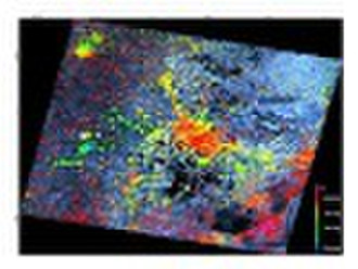
The INSAR monitoring center About our product: large area land deformation monitoringland subsidence monitoring landslides monitoring mining subsidence monitoring ground subsidence fine monitoring reservoir surrounding areas deformation monitoring railway, highway etc subsidence monitoring middle and small scale digital topographic map cloudy and rainy region digital map precision agriculture relevant applications (such as crop classification, distribution, yield estimation, etc. Example :Tianjin subsidence zone investigation and monitoring Since 2000 the China AGRS and German research center implement the land subsidence and monitoring in Tianjin areas, Which achieved very good results. The picture is Dezhou-Tianjin zone Subsidence figure (Shengfang area has a large subsidence rate). You can see that the subsidence rate in about 9 centimeters per year. After controlled by Tianjin government ,the subsidence rate been effectively reduced.
Условия поставки и упаковка
Порт: Changsha/Shenzhen
Условия оплаты
Аккредитив
Электронный перевод

-
Способы оплаты
Для оплаты товаров и услуг на нашем портале, Вы всегда получаете счет, в котором Вам необходимо самостоятельно указать свои данные.
Мы принимаем к оплате:


